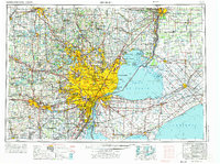
1961 Map of Detroit
USGS Topo · Published 1973About this map
Detroit serves as the focal point of this expansive international border region, showing the city's dense urban core and its mid-century industrial extension during a period of significant suburban growth. The sheet details the critical waterway connection between Lake Huron and Lake Erie, including the St Clair River and the Detroit River, which define the frontier between the United States and Canada. On the American side, the postwar expansion of the automotive industry is reflected in the sprawling residential networks of Warren, Livonia, and Dearborn, while the Canadian side features the rail and road hubs of Windsor and Sarnia.
Find a feature on this map
250 named features on this map. Tap any name to fly to it.
Don’t see what you’re looking for? This feature index may not catch every label — zoom into the map to look around manually.
Map Details
Editions of this 1961 Detroit Map
2 editions found

Other maps of this area

1902 · South Lyon
USGS Topo · 1:62,500

1902 · Ypsilanti
USGS Topo · 1:62,500

1902 · Dexter
USGS Topo · 1:62,500

1904 · Ann Arbor
USGS Topo · 1:125,000

1905 · Wayne
USGS Topo · 1:62,500

1905 · Detroit
USGS Topo · 1:62,500

1905 · Grosse Pointe
USGS Topo · 1:62,500

1906 · Ypsilanti
USGS Topo · 1:62,500

1906 · Wyandotte
USGS Topo · 1:62,500

1906 · Dexter
USGS Topo · 1:62,500