
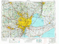
1961 Map of Detroit
USGS Topo · Published 1973About this map
Detroit and Windsor stand as the industrial and cultural anchors of this international border region, separated by the vital Detroit River and connected by the Detroit-Windsor Tunnel. In the early 1960s, the metropolitan landscape shows a dense network of expanding suburbs like Warren, Livonia, and Sterling Heights, transitioning into the state recreation areas of Oakland County to the north. This survey illustrates the era's heavy reliance on both massive rail systems like the Grand Trunk Western Railroad and a burgeoning interstate highway system, including Interstate 94 and Interstate 75. Beyond the urban core, the map details the maritime geography of Lake St. Clair, featuring Walpole Island and the military presence at Selfridge Air Force Base. The reach of the Great Lakes economy is evident in the inclusion of satellite cities like Ann Arbor, Flint, and Port Huron.
Find a feature on this map
313 named features on this map. Tap any name to fly to it.
Don’t see what you’re looking for? This feature index may not catch every label — zoom into the map to look around manually.
Map Details
Editions of this 1961 Detroit Map
2 editions found
Other maps of this area

1902 · South Lyon
USGS Topo · 1:62,500

1902 · Ypsilanti
USGS Topo · 1:62,500

1902 · Dexter
USGS Topo · 1:62,500

1904 · Ann Arbor
USGS Topo · 1:125,000

1905 · Wayne
USGS Topo · 1:62,500

1905 · Detroit
USGS Topo · 1:62,500

1905 · Grosse Pointe
USGS Topo · 1:62,500

1906 · Ypsilanti
USGS Topo · 1:62,500

1906 · Wyandotte
USGS Topo · 1:62,500

1906 · Dexter
USGS Topo · 1:62,500