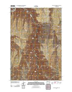
2011 Map of Devils Backbone
USGS Topo · Published 2011About this map
Potters Cemetery sits as a solitary landmark of human presence in this sparsely populated stretch of Sherman County. The landscape is defined by the significant hydrological influence of the John Day River and the winding course of Hay Creek, which carves through the terrain alongside the prominent ridge known as the Devils Backbone. This area, characterized by deep ravines like Sixmile Canyon and Spring Hollow, reflects a rural livestock and dryland farming environment where water sources such as Sevenmile Spring were essential for survival. Transport across these ridges and canyons is maintained by local routes including Hay Canyon Rd and Mikkalo Ln, providing access to isolated family-named landmarks and the rugged geography of the high plateau country.
Find a feature on this map
12 named features on this map. Tap any name to fly to it.
Don’t see what you’re looking for? This feature index may not catch every label — zoom into the map to look around manually.
Map Details
Editions of this 2011 Devils Backbone Map
This is the sole edition of this map. No revisions or reprints were ever made.
Other maps of this area

1916 · Arlington
USGS Topo · 1:125,000

1916 · Condon
USGS Topo · 1:125,000

1953 · The Dalles
USGS Topo · 1:250,000

1956 · The Dalles
USGS Topo · 1:250,000

1957 · The Dalles
USGS Topo · 1:250,000

1964 · Turner Butte
USGS Topo · 1:24,000

1964 · Shutler Flat
USGS Topo · 1:24,000

1964 · Mc Donald
USGS Topo · 1:24,000

1970 · Devils Backbone
USGS Topo · 1:24,000

1970 · Igo Butte
USGS Topo · 1:24,000