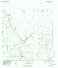
1983 Map of Devils Den
USGS Topo · Published 1983About this map
The University of Texas Radio Astronomy Observatory stands as a prominent technological landmark in this high-desert ranching landscape of Presidio County. The terrain is defined by deep incisions like Devils Den and Willow Canyon, which feed into the drainage of Alamito Creek and Perdiz Creek. Human activity in the early 1980s was primarily centered on pastoral infrastructure and scientific research, evidenced by a network of family-named water sources such as Lourdes Windmill and Chambers Windmill.
Find a feature on this map
28 named features on this map. Tap any name to fly to it.
Don’t see what you’re looking for? This feature index may not catch every label — zoom into the map to look around manually.
Map Details
Editions of this 1983 Devils Den Map
This is the sole edition of this map. No revisions or reprints were ever made.
Other maps of this area

1895 · Marfa
USGS Topo · 1:125,000

1895 · Alpine
USGS Topo · 1:125,000

1896 · Shafter
USGS Topo · 1:125,000

1918 · Jordan Gap
USGS Topo · 1:62,500

1930 · Jordan Gap
USGS Topo · 1:62,500

1954 · Fort Stockton
USGS Topo · 1:250,000

1958 · Fort Stockton
USGS Topo · 1:250,000

1959 · Emory Peak
USGS Topo · 1:250,000

1959 · Presidio
USGS Topo · 1:250,000

1959 · Marfa
USGS Topo · 1:250,000