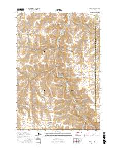
2017 Map of Devils Gap
USGS Topo · Published 2017About this map
Rock Creek and its many tributaries carve a complex network of drainages across this high-plateau landscape along the Gilliam and Morrow county line. The topography is dominated by a series of deeply etched canyons and hollows, including Cayuse Canyon, Wolf Hollow, and Sixmile Canyon. A notable cultural landmark is the Brown Cem, situated near Horse Hollow and the topographical namesake Devils Gap. The presence of Box Elder Spring at the head of Box Elder Canyon suggests the critical importance of localized water sources in this arid region. The map details an established network of local routes like Hale Ridge Rd and Cayuse Canyon Rd that follow the natural contours of the ridges and canyon floors, reflecting the long-standing ranching and land-management patterns of north-central Oregon.
Find a feature on this map
31 named features on this map. Tap any name to fly to it.
Don’t see what you’re looking for? This feature index may not catch every label — zoom into the map to look around manually.
Map Details
Editions of this 2017 Devils Gap Map
This is the sole edition of this map. No revisions or reprints were ever made.
Other maps of this area

1916 · Condon
USGS Topo · 1:125,000

1953 · Pendleton
USGS Topo · 1:250,000

1953 · The Dalles
USGS Topo · 1:250,000

1956 · The Dalles
USGS Topo · 1:250,000

1956 · Pendleton
USGS Topo · 1:250,000

1957 · The Dalles
USGS Topo · 1:250,000

1968 · Gooseberry
USGS Topo · 1:24,000
1968 · Utts Butte
USGS Topo · 1:24,000
1970 · Wolf Hollow Falls
USGS Topo · 1:24,000

1970 · Condon
USGS Topo · 1:24,000