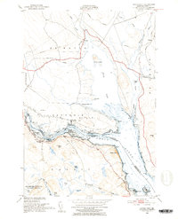
1949 Map of Devils Head
USGS Topo · Published 1952About this map
St Croix River currents define the international boundary in this detailed 1949 survey, which captures the rugged coastal character of Washington County and its Canadian neighbor, New Brunswick. The map highlights a landscape shaped by tidal water and early industry, featuring the Cribbing Ruins near Devils Head and the small settlement at Whitlocks Mill. Along the river's narrowest points, navigation aids like the Mark Lighthouse and a secondary Lighthouse near Elliott Mtn were essential for vessels transiting between Oak Bay and the open water.
Find a feature on this map
55 named features on this map. Tap any name to fly to it.
Don’t see what you’re looking for? This feature index may not catch every label — zoom into the map to look around manually.
Map Details
Editions of this 1949 Devils Head Map
4 editions found
Other maps of this area

1929 · Calais
USGS Topo · 1:48,000

1929 · Robbinston
USGS Topo · 1:48,000

1931 · Robbinston
USGS Topo · 1:62,500

1932 · Calais
USGS Topo · 1:62,500

1940 · Kellyland
USGS Topo · 1:62,500

1942 · Kellyland
USGS Topo · 1:62,500

1949 · Robbinston
USGS Topo · 1:24,000

1949 · Calais
USGS Topo · 1:24,000

1949 · Red Beach
USGS Topo · 1:24,000

1949 · Devils Head
USGS Topo · 1:24,000