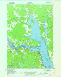
1949 Map of Devils Head
USGS Topo · Published 1978About this map
The St Croix River serves as the international boundary between Maine and New Brunswick in this mid-century topographic survey. The landscape is defined by its maritime and industrial connections, notably centered around Whitlocks Mill and the sweeping shoreline of Oak Bay. The rugged coastal topography includes prominent elevations like Devils Head and Elliott Mtn, while the interior is dominated by the marshy expanse of Carson Heath and the protected lands of the Moosehorn National Wildlife Refuge.
Find a feature on this map
51 named features on this map. Tap any name to fly to it.
Don’t see what you’re looking for? This feature index may not catch every label — zoom into the map to look around manually.
Map Details
Editions of this 1949 Devils Head Map
4 editions found
Other maps of this area

1929 · Calais
USGS Topo · 1:48,000

1929 · Robbinston
USGS Topo · 1:48,000

1931 · Robbinston
USGS Topo · 1:62,500

1932 · Calais
USGS Topo · 1:62,500

1940 · Kellyland
USGS Topo · 1:62,500

1942 · Kellyland
USGS Topo · 1:62,500

1949 · Robbinston
USGS Topo · 1:24,000

1949 · Calais
USGS Topo · 1:24,000

1949 · Red Beach
USGS Topo · 1:24,000

1949 · Devils Head
USGS Topo · 1:24,000