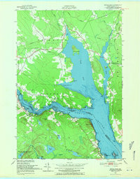
1949 Map of Devils Head
USGS Topo · Published 1971About this map
St Croix River currents define this international borderland, where the waterway narrows significantly at the Narrows near Whitlocks Mill. This mid-century survey captures the rugged coastline of Washington County and its transition into the wilderness of the Moosehorn National Wildlife Refuge. The landscape is a complex network of freshwater bodies, including Nashs Lake, Beaver Lake, and Vose Pond, which drain through the surrounding heaths and marshes.
Find a feature on this map
49 named features on this map. Tap any name to fly to it.
Don’t see what you’re looking for? This feature index may not catch every label — zoom into the map to look around manually.
Map Details
Editions of this 1949 Devils Head Map
4 editions found
Other maps of this area

1929 · Calais
USGS Topo · 1:48,000

1929 · Robbinston
USGS Topo · 1:48,000

1931 · Robbinston
USGS Topo · 1:62,500

1932 · Calais
USGS Topo · 1:62,500

1940 · Kellyland
USGS Topo · 1:62,500

1942 · Kellyland
USGS Topo · 1:62,500

1949 · Robbinston
USGS Topo · 1:24,000

1949 · Calais
USGS Topo · 1:24,000

1949 · Red Beach
USGS Topo · 1:24,000

1949 · Devils Head
USGS Topo · 1:24,000