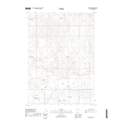
2017 Map of Devils Kitchen
USGS Topo · Published 2017About this map
Devils Kitchen anchors this landscape in Big Horn County, where the topography of the Bighorn Basin is defined by a complex network of ridges, draws, and irrigation infrastructure. The agricultural history of the region is evident in the engineered waterways, including Porter Canal, Shell Canal, and Whaley Ditch, which redirect water from Shell Cr to support the surrounding lands. Local history and genealogy are anchored at the Odessa Cem south of Potato Ridge. The map shows a transition from structured land use to more varied terrain near Herren Gulch and Sheldon Gulch. In the northern portion, the landscape is marked by industrial and transit routes like Bentonite Rd and Crystal Creek Rd, highlighting the intersection of resource extraction and local ranching travel patterns.
Find a feature on this map
32 named features on this map. Tap any name to fly to it.
Don’t see what you’re looking for? This feature index may not catch every label — zoom into the map to look around manually.
Map Details
Editions of this 2017 Devils Kitchen Map
This is the sole edition of this map. No revisions or reprints were ever made.
Other maps of this area

1898 · Bald Mountain
USGS Topo · 1:125,000

1901 · Bald Mountain
USGS Topo · 1:125,000

1955 · Cody
USGS Topo · 1:250,000

1955 · Sheridan
USGS Topo · 1:250,000

1958 · Cody
USGS Topo · 1:250,000

1958 · Sheridan
USGS Topo · 1:250,000

1960 · Manderson NE
USGS Topo · 1:24,000

1960 · Devils Kitchen
USGS Topo · 1:24,000

1960 · Shell
USGS Topo · 1:24,000

1960 · Bear Creek Ranch
USGS Topo · 1:24,000