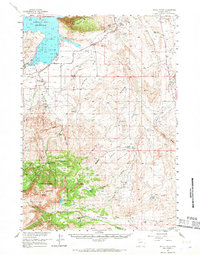
1957 Map of Devils Tooth
USGS Topo · Published 1968About this map
Buffalo Bill Reservoir dominates the northwestern corner of this landscape, its waters fed by the South Fork Shoshone River near a cluster of early homesteads and holdings. The mid-1950s terrain transitions from the irrigated Irma Flats and the industrial activity at the Sulphur Refinery to the high elevations of the Shoshone National Forest. This era shows a working land of ranching and early resource extraction, where the Spring Creek Oil Field and the Half Moon Field contrast with the rugged livestock operations at Diamond Bar Ranch, Carter Ranch, and Hoodoo Ranch. Evidence of early settlement persists in landmarks like the Grabbert Cabin and family-named features such as Pete Miller Park, while the prominent namesake peak of Devils Tooth stands as a focal point between the deep drainages of Meeteetse Creek and the heights of Carter Mountain.
Find a feature on this map
41 named features on this map. Tap any name to fly to it.
Don’t see what you’re looking for? This feature index may not catch every label — zoom into the map to look around manually.
Map Details
Editions of this 1957 Devils Tooth Map
4 editions found
Other maps of this area

1911 · Meeteetse
USGS Topo · 1:62,500

1911 · Oregon Basin
USGS Topo · 1:62,500

1913 · Oregon Basin
USGS Topo · 1:62,500

1913 · Meeteetse
USGS Topo · 1:62,500

1949 · Pat O'Hara Mountain
USGS Topo · 1:62,500

1949 · Cody
USGS Topo · 1:62,500

1951 · Cody
USGS Topo · 1:62,500

1955 · Cody
USGS Topo · 1:250,000

1957 · Wapiti
USGS Topo · 1:62,500

1957 · Devils Tooth
USGS Topo · 1:62,500