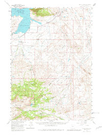
1957 Map of Devils Tooth
USGS Topo · Published 1981About this map
Buffalo Bill Reservoir dominates the northwestern corner of this landscape, where the South Fork Shoshone River feeds into the pool. This mid-century survey illustrates the ranching and industrial footprint at the edge of the Shoshone National Forest. Established ranching operations like Diamond Bar Ranch and Hoodoo Ranch occupy the lowlands, while the foothills are marked by the Sulphur Refinery and the Spring Creek Oil Field. The terrain climbs sharply toward the namesake Devils Tooth and the Shoshone Mountain range. The survey records a transition from the irrigated ranch lands of Irma Flats to the high timberline, providing an important record of resource extraction and family-owned properties such as Carter Ranch and the Grabbert Cabin during the late 1950s.
Find a feature on this map
40 named features on this map. Tap any name to fly to it.
Don’t see what you’re looking for? This feature index may not catch every label — zoom into the map to look around manually.
Map Details
Editions of this 1957 Devils Tooth Map
4 editions found
Other maps of this area

1911 · Meeteetse
USGS Topo · 1:62,500

1911 · Oregon Basin
USGS Topo · 1:62,500

1913 · Oregon Basin
USGS Topo · 1:62,500

1913 · Meeteetse
USGS Topo · 1:62,500

1949 · Pat O'Hara Mountain
USGS Topo · 1:62,500

1949 · Cody
USGS Topo · 1:62,500

1951 · Cody
USGS Topo · 1:62,500

1955 · Cody
USGS Topo · 1:250,000

1957 · Wapiti
USGS Topo · 1:62,500

1957 · Devils Tooth
USGS Topo · 1:62,500