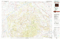
1979 Map of Devils Tower
USGS Topo · Published 1979About this map
The Devils Tower National Monument stands as the central landmark of this landscape, surrounded by the diverse terrain of the Black Hills and the Bear Lodge Mountains. The Belle Fourche River and the Little Missouri River drain the region, creating a network of valleys that historically supported small settlements like Hulett, Aladdin, and Beulah. This 1979 survey captures the area at a time when traditional ranching and timber interests in the Black Hills National Forest coexisted with heavy industry, evidenced by the Chicago and North Western railroad line and various Clay Pits near the Montana border.
Find a feature on this map
51 named features on this map. Tap any name to fly to it.
Don’t see what you’re looking for? This feature index may not catch every label — zoom into the map to look around manually.
Map Details
Editions of this 1979 Devils Tower Map
2 editions found
Other maps of this area

1894 · Deadwood
USGS Topo · 1:125,000

1898 · Sundance
USGS Topo · 1:125,000

1900 · Spearfish
USGS Topo · 1:62,500

1901 · Deadwood
USGS Topo · 1:125,000

1901 · Aladdin
USGS Topo · 1:125,000

1902 · Sundance
USGS Topo · 1:125,000

1903 · Aladdin
USGS Topo · 1:125,000

1905 · Devils Tower
USGS Topo · 1:125,000

1905 · Indian
USGS Topo · 1:62,500

1907 · Belle Fourche
USGS Topo · 1:125,000