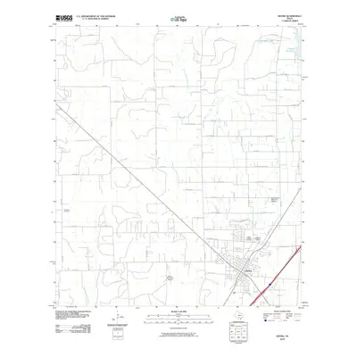
2010 Map of Devine
USGS Topo · Published 2010About this map
Devine serves as the focal point of this South Texas landscape, where the intersection of rural farm-to-market roads and newer development patterns is clearly visible. The drainage network is particularly dense here, defined by the winding paths of San Francisco Perez Creek, Burnt Boot Creek, and Black Creek, which weave through the agricultural and residential plots. To the northeast, the Chacon Reservoir and Jungman Lake provide significant water resources, while the presence of the Medina Lake State Fish Hatchery indicates the region's involvement in conservation and resource management.
Find a feature on this map
58 named features on this map. Tap any name to fly to it.
Don’t see what you’re looking for? This feature index may not catch every label — zoom into the map to look around manually.
Map Details
Editions of this 2010 Devine Map
This is the sole edition of this map. No revisions or reprints were ever made.
Other maps of this area

1942 · Natalia
USGS Topo · 1:62,500

1954 · San Antonio
USGS Topo · 1:250,000

1956 · New Fountain
USGS Topo · 1:62,500

1957 · San Antonio
USGS Topo · 1:250,000

1958 · La Coste
USGS Topo · 1:24,000

1964 · Ghost Hill
USGS Topo · 1:24,000

1964 · Castroville
USGS Topo · 1:24,000

1964 · Devine
USGS Topo · 1:24,000
1964 · Moore
USGS Topo · 1:24,000
1964 · Lytle
USGS Topo · 1:24,000