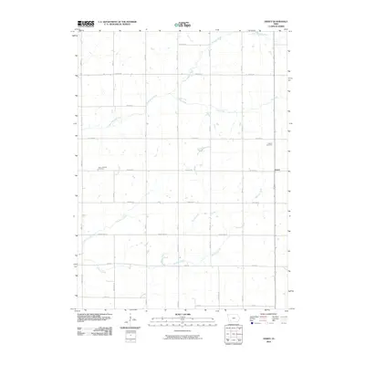
2010 Map of Dewey
USGS Topo · Published 2010About this map
Agricultural lands and seasonal waterways define this pocket of Cass County, Iowa, just before the turn of the decade. The West Nodaway River and its various tributaries, including Elm Creek and Williams Creek, form a dendritic drainage pattern across the landscape, influencing the placement of local thoroughfares. The small settlement of Dewey sits at the intersection of Wichita Rd and Highway 148, serving as a quiet focal point in a region dominated by family farms. Local history and genealogy are anchored by established burial grounds like Saint Timothy Cemetery and Victoria Cemetery, which remain connected to the surrounding community by a rigid grid of gravel and paved roads. The map's detail reflects the transition from early section-line roads to modern routes, such as Tucson Rd and Yankton Rd, while preserving the original creek-side topography.
Find a feature on this map
32 named features on this map. Tap any name to fly to it.
Don’t see what you’re looking for? This feature index may not catch every label — zoom into the map to look around manually.
Map Details
Editions of this 2010 Dewey Map
This is the sole edition of this map. No revisions or reprints were ever made.
Other maps of this area

1954 · Omaha
USGS Topo · 1:250,000

1957 · Omaha
USGS Topo · 1:250,000

1958 · Omaha
USGS Topo · 1:250,000

1971 · Anita SW
USGS Topo · 1:24,000

1971 · Massena
USGS Topo · 1:24,000

1971 · Fontanelle SW
USGS Topo · 1:24,000

1980 · Corning North
USGS Topo · 1:24,000

1980 · Grant
USGS Topo · 1:24,000

1980 · Bridgewater
USGS Topo · 1:24,000
1980 · Carbon
USGS Topo · 1:24,000