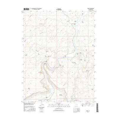
2017 Map of Dewey
USGS Topo · Published 2017About this map
The Colorado River carves a dramatic path through this high desert region of Grand County, Utah, where it meets the Dolores River near the small settlement of Dewey. The landscape is defined by its massive river bottoms and sheer canyon walls, including the expansive Richardson Amphitheater and the distinctively named Mule Shoe bend. The iconic Dewey Bridge provides a critical crossing point for travelers moving through the canyons toward Professor Valley. High above the river corridor, the terrain transitions into complex plateaus and mesas like the Little Pinto Mesa and the Owl Draw Upland. This 2017 survey details a landscape where traditional transit routes, such as Gold Mine Rd and Fisher Tower Rd, follow the natural contours of the canyons, highlighting the area's isolation and its historical reliance on the river as the primary geographic anchor.
Find a feature on this map
45 named features on this map. Tap any name to fly to it.
Don’t see what you’re looking for? This feature index may not catch every label — zoom into the map to look around manually.
Map Details
Editions of this 2017 Dewey Map
This is the sole edition of this map. No revisions or reprints were ever made.
Other maps of this area

1885 · La Sal
USGS Topo · 1:250,000

1954 · Mt. Waas 4 NW
USGS Topo · 1:24,000

1954 · Mt. Waas 3 NE
USGS Topo · 1:24,000

1954 · Mt. Waas 1 SW
USGS Topo · 1:24,000

1954 · Mt. Waas 3 NW
USGS Topo · 1:24,000

1954 · Mt. Waas 1 NW
USGS Topo · 1:24,000

1954 · Coates Creek
USGS Topo · 1:62,500

1954 · Polar Mesa
USGS Topo · 1:62,500

1954 · Castle Valley
USGS Topo · 1:62,500

1955 · Mt. Waas 2 SE
USGS Topo · 1:24,000