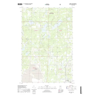
2019 Map of Dewey Lake
USGS Topo · Published 2019About this map
Superior National Forest dominates the landscape of this 2019 survey, characterized by the dense network of glacial lakes and wetlands typical of northern Minnesota. The industrial footprint of the Iron Range is vividly captured in the southwestern corner, where the Hibbing Taconite Tailings Basin occupies a significant portion of the terrain, reflecting the area's enduring mining heritage. The map details the transition from the wilder forested areas to the settled corridors of Hibbing and Chisholm. Water bodies like Dewey Lake, Island Lake, and the winding Shannon River provide geographic structure to a region defined by its timber and mineral wealth. Local researchers can identify numerous rural roads, such as Hyvarinen Rd and Krogerus Rd, alongside significant landmarks like Calvary Cem, documenting the modern layout of Saint Louis County.
Find a feature on this map
57 named features on this map. Tap any name to fly to it.
Don’t see what you’re looking for? This feature index may not catch every label — zoom into the map to look around manually.
Map Details
Editions of this 2019 Dewey Lake Map
This is the sole edition of this map. No revisions or reprints were ever made.
Other maps of this area

1951 · Hibbing
USGS Topo · 1:24,000

1951 · Buhl
USGS Topo · 1:24,000

1952 · Keewatin
USGS Topo · 1:24,000

1954 · Hibbing
USGS Topo · 1:250,000

1955 · Dark Lake
USGS Topo · 1:24,000

1955 · Dewey Lake SE
USGS Topo · 1:24,000

1955 · Dewey Lake NW
USGS Topo · 1:24,000

1955 · Dewey Lake
USGS Topo · 1:24,000

1957 · Hibbing
USGS Topo · 1:250,000

1957 · Hibbing
USGS Topo · 1:24,000