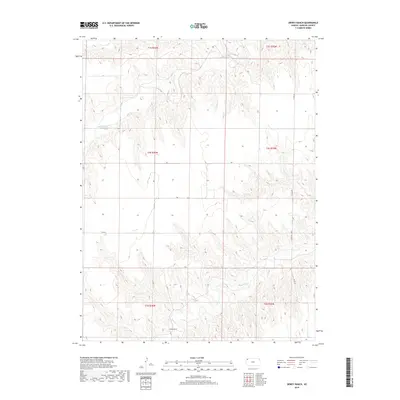
2018 Map of Dewey Ranch
USGS Topo · Published 2018About this map
Dewey Ranch anchors the southern reaches of this High Plains landscape, situated along the winding course of Beaver Creek. The terrain is defined by the complex drainage systems of both Beaver Creek and its northern counterpart, Little Beaver Creek, which carve deep, branching draws into the Rawlins County uplands. This 2018 survey illustrates a rural environment shaped by the Public Land Survey System, with township and range lines like t4s r36w and t5s r35w partitioning the territory into a rigid grid. The local transportation network relies on a series of numbered and lettered section-line roads, including County Road 407 and Road G, which provide access through the undulating breaks. The map captures a contemporary look at traditional Kansas ranching country where water sources remains the primary driver of settlement and land use.
Find a feature on this map
21 named features on this map. Tap any name to fly to it.
Don’t see what you’re looking for? This feature index may not catch every label — zoom into the map to look around manually.
Map Details
Editions of this 2018 Dewey Ranch Map
This is the sole edition of this map. No revisions or reprints were ever made.
Other maps of this area

1950 · Mc Donald
USGS Topo · 1:62,500

1951 · Mc Donald
USGS Topo · 1:62,500

1951 · Atwood
USGS Topo · 1:62,500

1951 · Chardon
USGS Topo · 1:62,500

1951 · Dewey Ranch
USGS Topo · 1:62,500

1954 · Goodland
USGS Topo · 1:250,000

1956 · Goodland
USGS Topo · 1:250,000

1957 · Goodland
USGS Topo · 1:250,000
1978 · Beardsley
USGS Topo · 1:24,000
1978 · Mc Donald SW
USGS Topo · 1:24,000