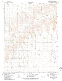
1981 Map of Dewey Ranch SW
USGS Topo · Published 1981About this map
Beaver Creek winds through a high plains landscape where four Kansas counties—Cheyenne, Rawlins, Sherman, and Thomas—all converge. This 1981 survey documents a transition in land use, where traditional prairie landmarks like Central Ch and the remote Fairview Cem near the Barrett district share the map with industrial developments. The presence of the Llanos Oil Field and several Sandpit sites indicate the extraction economy of the late 20th century. Topographic contours reveal the drainage patterns into the creek valleys, contrasting with the vast, relatively flat expanses of the Llanos and Bird City survey areas that dominate the northern and central sections.
Find a feature on this map
12 named features on this map. Tap any name to fly to it.
Don’t see what you’re looking for? This feature index may not catch every label — zoom into the map to look around manually.
Map Details
Editions of this 1981 Dewey Ranch SW Map
This is the sole edition of this map. No revisions or reprints were ever made.
Other maps of this area

1951 · Bird City South
USGS Topo · 1:62,500

1951 · Dewey Ranch
USGS Topo · 1:62,500

1954 · Goodland
USGS Topo · 1:250,000

1956 · Goodland
USGS Topo · 1:250,000

1957 · Goodland
USGS Topo · 1:250,000

1966 · Goodland NE
USGS Topo · 1:24,000

1966 · Brewster NW
USGS Topo · 1:24,000

1967 · Brewster NE
USGS Topo · 1:24,000
1981 · Dewey Ranch
USGS Topo · 1:24,000
1981 · Dewey Ranch NW
USGS Topo · 1:24,000