Loading...
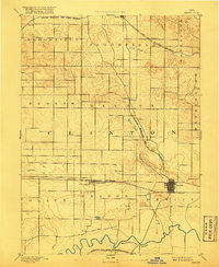
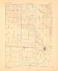
Loading map...1891 Map of DeWitt
USGS Topo · Published 1917About this map
The Wapsipinicon River meanders along the southern edge of this Clinton County landscape, defining the agricultural character of the region in the late 19th century. Surveyed in 1889, the area is crisscrossed by three major rail lines that fueled the growth of interior prairie settlements. The Chicago and North Western Railroad serves as a primary east-west corridor, linking Calamus, Grand Mound, and the established street grid of Dewitt.
Find a feature on this map
25 named features on this map. Tap any name to fly to it.
Don’t see what you’re looking for? This feature index may not catch every label — zoom into the map to look around manually.
Map Details
Date Portrayed1891
Date Published1917
PublisherU.S. Geological Survey
Map TypeTopographic
Scale1:62,500
Physical Dimensions16 x 19.6 inches
Editions of this 1891 DeWitt Map
3 editions found

Historical Maps of DeWitt Through Time
1 maps found
Featured Locations
Source Details
SourceU.S. Geological Survey
CopyrightPublic Domain