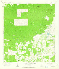
1962 Map of Dewville
USGS Topo · Published 1963About this map
The small settlement of Dewville serves as a southern anchor for this 1960s survey of the South Texas brush country. Deep within the landscape, the Capote Hills and Capote Knob rise above a dense network of watercourses including Cordell Creek and Sandies Creek. The map documents a period of ranching and early petroleum exploration, indicated by scattered Oil Well sites and established spreads like Escondido Ranch and Wells Ranch.
Find a feature on this map
23 named features on this map. Tap any name to fly to it.
Don’t see what you’re looking for? This feature index may not catch every label — zoom into the map to look around manually.
Map Details
Editions of this 1962 Dewville Map
2 editions found
Other maps of this area

1911 · San Marcos
USGS Topo · 1:125,000

1919 · San Marcos
USGS Topo · 1:125,000

1920 · Smiley
USGS Topo · 1:125,000

1924 · San Marcos 3-c
USGS Topo · 1:48,000

1924 · San Marcos 3-d
USGS Topo · 1:48,000

1925 · San Marcos 4-c
USGS Topo · 1:48,000

1929 · Luling
USGS Topo · 1:62,500

1930 · Seguin
USGS Topo · 1:62,500

1942 · Dewville
USGS Topo · 1:62,500

1953 · Seguin
USGS Topo · 1:250,000