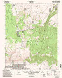
1994 Map of Dexter Canyon
USGS Topo · Published 1997About this map
Inyo National Forest dominates this high-elevation landscape, where numerous springs and meadows support a complex drainage system within the Sierra Nevada foothills. The terrain is defined by dramatic relief, ranging from Sagehen Peak and the high plateaus of Wild Horse Meadow down to the carved depths of Dexter Canyon and Wet Canyon. A network of 4WD trails provides the primary access through these ridges, connecting remote landmarks like Crooked Meadows and Johnny Meadow. In the southern reaches, the land levels into Long Valley, where the Owens River and man-made features like a Ditch reveal the vital role of water management in this arid region. The presence of a Sentinel Meadow Research Natural Area underscores the ecological significance of the riparian zones around Sentinel Meadow and Mc Laughlin Springs. Traces of early industrial activity appear in the northeast, marked by an Adit and various Prospects.
Find a feature on this map
30 named features on this map. Tap any name to fly to it.
Don’t see what you’re looking for? This feature index may not catch every label — zoom into the map to look around manually.
Map Details
Editions of this 1994 Dexter Canyon Map
This is the sole edition of this map. No revisions or reprints were ever made.
Other maps of this area

1914 · Mt. Morrison
USGS Topo · 1:125,000

1947 · Mariposa
USGS Topo · 1:250,000

1948 · Mariposa
USGS Topo · 1:250,000

1953 · Mt. Morrison
USGS Topo · 1:62,500

1953 · Casa Diablo Mtn
USGS Topo · 1:62,500

1957 · Mariposa
USGS Topo · 1:250,000

1962 · Cowtrack Mtn
USGS Topo · 1:62,500

1962 · Glass Mountain
USGS Topo · 1:62,500

1963 · Mariposa
USGS Topo · 1:250,000
1983 · Whitmore Hot Sprs
USGS Topo · 1:24,000