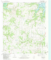
1982 Map of Dexter
USGS Topo · Published 1983About this map
The rolling landscape along the Red River border between Cooke and Grayson Counties is defined by the expansive waters of Lake Texoma and a deeply ingrained petroleum economy. This early 1980s landscape shows the transition from traditional agriculture to energy extraction, with extensive drilling operations visible in the North McMillan Oil Field and Philpick Oil Field. Small settlements like Dexter and Sandusky anchor the local road network, while several family and community burial grounds, including Shiloh Cem and Mt Zion Cem, speak to the area's pioneer heritage before the reservoir's creation. The northern reaches show a focus on water-based recreation and conservation, featuring the Sheppard AFB Recreation Area and a dedicated Fish Hatchery near the meandering North Branch.
Find a feature on this map
37 named features on this map. Tap any name to fly to it.
Don’t see what you’re looking for? This feature index may not catch every label — zoom into the map to look around manually.
Map Details
Editions of this 1982 Dexter Map
2 editions found
Other maps of this area

1901 · Denison
USGS Topo · 1:125,000

1902 · Gainesville
USGS Topo · 1:125,000

1943 · Gainesville
USGS Topo · 1:125,000

1954 · Sherman
USGS Topo · 1:250,000

1958 · Gordonville
USGS Topo · 1:62,500

1958 · Whitesboro
USGS Topo · 1:62,500

1958 · Sherman
USGS Topo · 1:250,000

1960 · Callisburg
USGS Topo · 1:24,000
1967 · Marietta East
USGS Topo · 1:24,000
1968 · Horseshoe Bend
USGS Topo · 1:24,000