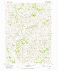
1981 Map of Diagonal
USGS Topo · Published 1981About this map
Diagonal serves as the primary hub of this rural Ringgold County landscape, situated where the Chicago And North Western railroad line cuts through the countryside. The geography is defined by the winding course of the Grand River, which is joined by numerous tributaries including Squaw Creek, Indian Creek, and West Plum Creek. The town of Knowlton appears just north of Diagonal, highlighting a period of close-knit rail-oriented settlements.
Find a feature on this map
21 named features on this map. Tap any name to fly to it.
Don’t see what you’re looking for? This feature index may not catch every label — zoom into the map to look around manually.
Map Details
Editions of this 1981 Diagonal Map
This is the sole edition of this map. No revisions or reprints were ever made.
Other maps of this area

1940 · Blockton
USGS Topo · 1:62,500

1943 · Blockton
USGS Topo · 1:62,500

1945 · Mount Ayr
USGS Topo · 1:62,500

1947 · Mount Ayr
USGS Topo · 1:62,500

1955 · Nebraska City
USGS Topo · 1:250,000

1957 · Nebraska City
USGS Topo · 1:250,000

1958 · Nebraska City
USGS Topo · 1:250,000
1981 · Arispe
USGS Topo · 1:24,000
1981 · Shannon City
USGS Topo · 1:24,000
1981 · Maloy
USGS Topo · 1:24,000