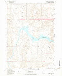
1967 Map of Diamond Butte
USGS Topo · Published 1983About this map
Owyhee Lake dominates this high-desert landscape in Malheur County, where the water's surface reflects a normal pool elevation of 2655 feet. The reservoir, created by the damming of the Owyhee River, is framed by dramatic geological features such as the Breaks and a prominent ridge known as The Tongue. Historical traces of former settlement remain at Watson Cem, situated on a point of land overlooking the eastern shore.
Find a feature on this map
24 named features on this map. Tap any name to fly to it.
Don’t see what you’re looking for? This feature index may not catch every label — zoom into the map to look around manually.
Map Details
Editions of this 1967 Diamond Butte Map
3 editions found
Other maps of this area

1955 · Boise
USGS Topo · 1:250,000

1958 · Boise
USGS Topo · 1:250,000

1962 · Boise
USGS Topo · 1:250,000

1967 · Pelican Point
USGS Topo · 1:24,000

1967 · Diamond Butte
USGS Topo · 1:24,000

1967 · Rooster Comb
USGS Topo · 1:24,000

1967 · Quartz Mtn Basin
USGS Topo · 1:24,000

1969 · Mc Cain Creek
USGS Topo · 1:24,000

1969 · Jordan Craters North
USGS Topo · 1:24,000

1972 · Big Mud Flat
USGS Topo · 1:24,000