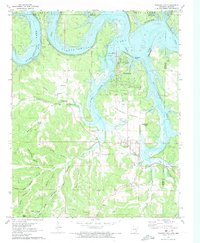
1972 Map of Diamond City
USGS Topo · Published 1973About this map
Bull Shoals Lake and the White River define this corner of the Ozarks along the Arkansas-Missouri state line. By the early 1970s, the landscape reflects a shift from traditional hill-country farming toward recreation and lakeside development, centered around Diamond City and its Landing Strip. Despite this modernization, the map remains a primary resource for tracing the deep-rooted family history of the Sugarloaf Prairie region. Many small family burial grounds are documented, including Pickard Cem, Raley Cem, and Carrollton Hollow Cem, alongside the Lead Hill Sch and Enon Ch.
Find a feature on this map
62 named features on this map. Tap any name to fly to it.
Don’t see what you’re looking for? This feature index may not catch every label — zoom into the map to look around manually.
Map Details
Editions of this 1972 Diamond City Map
This is the sole edition of this map. No revisions or reprints were ever made.
Other maps of this area

1893 · Yellville
USGS Topo · 1:125,000

1903 · Yellville
USGS Topo · 1:125,000

1904 · Harrison
USGS Topo · 1:125,000

1905 · Harrison
USGS Topo · 1:125,000

1905 · Yellville
USGS Topo · 1:125,000

1907 · Forsyth
USGS Topo · 1:125,000

1929 · Yellville
USGS Topo · 1:125,000

1943 · Protem
USGS Topo · 1:62,500

1945 · Harrison
USGS Topo · 1:250,000

1949 · Harrison
USGS Topo · 1:250,000