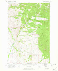
1966 Map of Diamond City
USGS Topo · Published 1970About this map
Diamond City serves as the focal point of this mid-1960s survey, marking a location where once-active mining operations have transitioned to historical footprints. The landscape is defined by the steep drainage basins of Confederate Creek and its many tributaries, including Montana Gulch and Cement Gulch, which cut through the protected lands of the Helena National Forest. Evidence of a past era's industry is scattered throughout these gulches, from the Miller Mine in the north to numerous unnamed mines and a prospect near Boulder Creek.
Find a feature on this map
32 named features on this map. Tap any name to fly to it.
Don’t see what you’re looking for? This feature index may not catch every label — zoom into the map to look around manually.
Map Details
Editions of this 1966 Diamond City Map
2 editions found
Other maps of this area

1886 · Fort Logan
USGS Topo · 1:250,000

1948 · White Sulphur Springs
USGS Topo · 1:250,000

1950 · Canyon Ferry
USGS Topo · 1:62,500

1950 · Townsend
USGS Topo · 1:62,500

1950 · Duck Creek Pass
USGS Topo · 1:62,500

1958 · White Sulphur Springs
USGS Topo · 1:250,000

1961 · White Sulphur Springs
USGS Topo · 1:250,000

1965 · White Sulphur Springs
USGS Topo · 1:250,000

1966 · Boulder Baldy
USGS Topo · 1:24,000

1966 · Diamond City
USGS Topo · 1:24,000