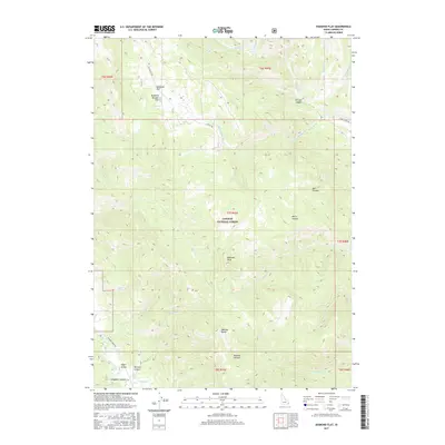
2017 Map of Diamond Flat
USGS Topo · Published 2017About this map
Caribou National Forest dominates this section of eastern Idaho, where the high ridges of the Webster Range define the local topography. At the northern end of this reach, the landscape opens into the high mountain basins of Diamond Flat and Diamond Boulder Flat, historically significant grazing and passage areas. Traces of western expansion are preserved in the path of the Lander Trl, an early immigrant route that cut through these drainages. The map details a complex network of canyons and creeks, such as Mill Canyon and Stump Cr, which have served as critical water sources for livestock and local wildlife for generations. High points like Diamond Peak overlook a system of seasonal camps and ranching outposts in Upper Valley, illustrating the long-standing use of these public lands for both transit and mountain industry.
Find a feature on this map
38 named features on this map. Tap any name to fly to it.
Don’t see what you’re looking for? This feature index may not catch every label — zoom into the map to look around manually.
Map Details
Editions of this 2017 Diamond Flat Map
This is the sole edition of this map. No revisions or reprints were ever made.
Other maps of this area

1911 · Slug Creek
USGS Topo · 1:62,500

1915 · Freedom
USGS Topo · 1:62,500

1915 · Crow Creek
USGS Topo · 1:62,500

1915 · Lanes Creek
USGS Topo · 1:62,500

1949 · Stewart Flat
USGS Topo · 1:24,000

1949 · Dry Valley
USGS Topo · 1:24,000
1951 · Upper Valley
USGS Topo · 1:24,000

1951 · Stewart Flat
USGS Topo · 1:24,000
1951 · Dry Valley
USGS Topo · 1:24,000

1955 · Preston
USGS Topo · 1:250,000