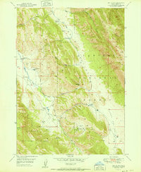
1951 Map of Dry Valley
USGS Topo · Published 1951About this map
Caribou National Forest dominates this Idaho landscape, where a series of family ranches line the narrow valleys between high ridges. Based on aerial photography from 1947 and a 1949 field check, the survey reveals a remote high-altitude ranching economy centered around Schmid Ridge. The drainage of Slug Creek and Dry Valley Creek provides the primary geography for these scattered operations, including the Stewart Ranch, Young Ranch, and Petterson Ranch. The map also details early prospecting efforts through various prospect sites, particularly near the Dry Basin. Administrative presence is noted at the Dry Valley Guard Sta, while the rugged terrain is carved by named draws like Caldwell Canyon and Hornet Canyon. This documentation offers a precise record of the mid-century grazing and mineral exploration footprint in eastern Idaho.
Find a feature on this map
44 named features on this map. Tap any name to fly to it.
Don’t see what you’re looking for? This feature index may not catch every label — zoom into the map to look around manually.
Map Details
Editions of this 1951 Dry Valley Map
This is the sole edition of this map. No revisions or reprints were ever made.
Other maps of this area

1911 · Slug Creek
USGS Topo · 1:62,500

1915 · Freedom
USGS Topo · 1:62,500

1915 · Crow Creek
USGS Topo · 1:62,500

1915 · Lanes Creek
USGS Topo · 1:62,500

1949 · Johnson Creek
USGS Topo · 1:24,000

1949 · Stewart Flat
USGS Topo · 1:24,000

1949 · Dry Valley
USGS Topo · 1:24,000

1949 · Snowdrift Mountain
USGS Topo · 1:24,000

1949 · Lower Valley
USGS Topo · 1:24,000

1951 · Lower Valley
USGS Topo · 1:24,000