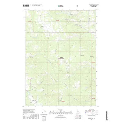
2020 Map of Diamond Flat
USGS Topo · Published 2020About this map
Diamond Flat and Diamond Boulder Flat sit at the northern edge of this high-elevation landscape within the Caribou National Forest. The map documents a complex system of canyon and ridge travel, most notably the historical Lander Trail and its connection through Lander Trail-Terrace Canyon. These routes imply the historical importance of this corridor for transcontinental movement and local livestock management. The topography is dominated by the Webster Range and Webster Ridge, which drop sharply into Webster Canyon and Terrace Canyon. To the south, the settlement at Upper Valley is reached by Old Road 395, while more remote reaches are accessed via the Yellowjacket Access. Numerous drainages including Stump Creek, Timothy Creek, and Bechler Creek carve through the high country, centering on the prominent Diamond Peak.
Find a feature on this map
54 named features on this map. Tap any name to fly to it.
Don’t see what you’re looking for? This feature index may not catch every label — zoom into the map to look around manually.
Map Details
Editions of this 2020 Diamond Flat Map
This is the sole edition of this map. No revisions or reprints were ever made.
Other maps of this area

1911 · Slug Creek
USGS Topo · 1:62,500

1915 · Freedom
USGS Topo · 1:62,500

1915 · Crow Creek
USGS Topo · 1:62,500

1915 · Lanes Creek
USGS Topo · 1:62,500

1949 · Stewart Flat
USGS Topo · 1:24,000

1949 · Dry Valley
USGS Topo · 1:24,000
1951 · Upper Valley
USGS Topo · 1:24,000

1951 · Stewart Flat
USGS Topo · 1:24,000
1951 · Dry Valley
USGS Topo · 1:24,000

1955 · Preston
USGS Topo · 1:250,000