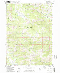
1980 Map of Diamond Flat
USGS Topo · Published 1980About this map
The Lander Cutoff of the Emigrant Trail bisects the northern reaches of this landscape, marking a vital historical corridor for westward travelers. Set within the Caribou National Forest, the terrain is defined by the high peaks of the Webster Range, culminating at Diamond Peak. The survey reveals a complex network of canyons and drainage systems, including Yellowjacket Canyon, Campbell Canyon, and Mill Canyon, which funnel seasonal waters into larger creeks like Stump Creek.
Find a feature on this map
30 named features on this map. Tap any name to fly to it.
Don’t see what you’re looking for? This feature index may not catch every label — zoom into the map to look around manually.
Map Details
Editions of this 1980 Diamond Flat Map
This is the sole edition of this map. No revisions or reprints were ever made.
Other maps of this area

1911 · Slug Creek
USGS Topo · 1:62,500

1915 · Freedom
USGS Topo · 1:62,500

1915 · Crow Creek
USGS Topo · 1:62,500

1915 · Lanes Creek
USGS Topo · 1:62,500

1949 · Stewart Flat
USGS Topo · 1:24,000

1949 · Dry Valley
USGS Topo · 1:24,000
1951 · Upper Valley
USGS Topo · 1:24,000

1951 · Stewart Flat
USGS Topo · 1:24,000
1951 · Dry Valley
USGS Topo · 1:24,000

1955 · Preston
USGS Topo · 1:250,000