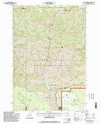
1995 Map of Diamond Peak
USGS Topo · Published 1998About this map
Umatilla National Forest defines this high-elevation landscape on the border of Columbia and Garfield counties, where the protected terrain of the Wenaha-Tucannon Wilderness dominates the central topography. Significant landmarks like Diamond Peak and Mt Misery anchor the ridges, overlooking a complex system of drainages including Coyote Creek and Crooked Creek. The map reveals a land structured by ridges and flats, with Monument Ridge and Smooth Ridge rising above grazing areas like Moore Flat and Grouse Flat. Human activity in this mid-1990s survey is represented by remote outposts such as Kelly Camp and the F Kessler Ranch near the southern boundary. A network of primitive routes, including the Diamond Road and Driveway Ridge Trail, provides access across the drainage of Three Forks, connecting isolated springs like Pistol Spring and Fairview Spring.
Find a feature on this map
41 named features on this map. Tap any name to fly to it.
Don’t see what you’re looking for? This feature index may not catch every label — zoom into the map to look around manually.
Map Details
Editions of this 1995 Diamond Peak Map
This is the sole edition of this map. No revisions or reprints were ever made.
Other maps of this area

1937 · Pomeroy
USGS Topo · 1:96,000

1942 · Pomeroy
USGS Topo · 1:125,000

1943 · Saddle Butte
USGS Topo · 1:62,500

1946 · Saddle Butte
USGS Topo · 1:62,500

1955 · Pullman
USGS Topo · 1:250,000

1955 · Grangeville
USGS Topo · 1:250,000

1958 · Pullman
USGS Topo · 1:250,000

1959 · Grangeville
USGS Topo · 1:250,000

1967 · Troy
USGS Topo · 1:24,000

1967 · Eden
USGS Topo · 1:24,000