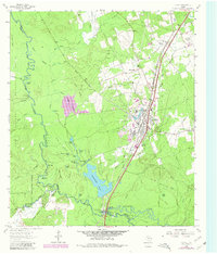
1963 Map of Diboll
USGS Topo · Published 1980About this map
The Neches River forms a complex riparian boundary on this 1963 survey, as revised in 1980, separating the Angelina National Forest and Davy Crockett National Forest. The industrial hub of Diboll dominates the eastern corridor, shaped by the Southern Pacific railroad and the Texas South-Eastern line. The map captures a landscape transitioning from the river-bottom swamps of The Sucks and Yellow Bluff Lake to the organized timber and mill industry evidenced by Fiberboard Lake. Local history is anchored by Ryan Chapel and Clarks Ferry, while the presence of an Old Railroad Grade and several family-named landmarks like Mc Carty Cem and Hooper Bluff provide critical details for genealogists studying the deep woods of East Texas.
Find a feature on this map
66 named features on this map. Tap any name to fly to it.
Don’t see what you’re looking for? This feature index may not catch every label — zoom into the map to look around manually.
Map Details
Editions of this 1963 Diboll Map
2 editions found
Other maps of this area

1927 · Lufkin 4-c
USGS Topo · 1:24,000

1932 · Manning
USGS Topo · 1:62,500

1949 · Lufkin
USGS Topo · 1:62,500

1949 · Lufkin
USGS Topo · 1:24,000

1949 · Keltys
USGS Topo · 1:24,000

1950 · Keltys
USGS Topo · 1:24,000

1950 · Lufkin
USGS Topo · 1:24,000

1951 · Wells SW
USGS Topo · 1:24,000

1953 · Palestine
USGS Topo · 1:250,000

1957 · Palestine
USGS Topo · 1:250,000