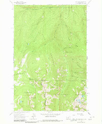
1964 Map of Dick Creek
USGS Topo · Published 1980About this map
Lolo National Forest and the Selway-Bitterroot Wilderness dominate this 1964 survey of the Bitterroot Mountains along the Montana and Idaho border. The landscape is defined by the high-elevation drainages of Lolo Creek and its major tributaries, including South Fork Lolo Creek and Dick Creek. While the area is primarily undeveloped wilderness, evidence of early resource extraction is visible at the Ward Lode Mine on the western slopes. A network of Pack Trails and occasional Jeep Trails provide the only access through the dense topography.
Find a feature on this map
35 named features on this map. Tap any name to fly to it.
Don’t see what you’re looking for? This feature index may not catch every label — zoom into the map to look around manually.
Map Details
Editions of this 1964 Dick Creek Map
3 editions found
Other maps of this area

1912 · Missoula
USGS Topo · 1:125,000

1956 · Hamilton
USGS Topo · 1:250,000

1959 · Hamilton
USGS Topo · 1:250,000

1960 · Hamilton
USGS Topo · 1:250,000

1964 · Hamilton
USGS Topo · 1:250,000

1964 · Garden Point
USGS Topo · 1:24,000

1964 · Dick Creek
USGS Topo · 1:24,000

1964 · West Fork Butte
USGS Topo · 1:24,000
1964 · Blue Mountain
USGS Topo · 1:24,000
1964 · Camp Creek
USGS Topo · 1:24,000