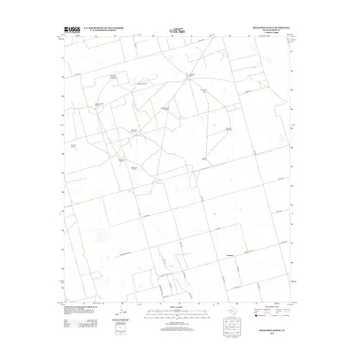
2012 Map of Dickenson Ranch
USGS Topo · Published 2012About this map
Dickenson Ranch anchors this portion of Martin County, where the landscape is defined by a sparse network of county roads and essential water infrastructure. The small settlement of Courtney sits in the southern half of the quadrangle, serving as a hub for local ranching activity. A significant hydrological feature, Mustang Spring, provides a critical water source in this semi-arid environment, which is heavily reliant on wind power for livestock operations. Numerous named windmills are scattered across the terrain, reflecting family and topographic identifiers such as Northeast Sunflower Windmill, Rattlesnake Windmill, and the Windmill on the Hill. This pattern of named windmills and cattle tanks suggests a ranching economy that has remained remarkably consistent in its spatial organization into the early twenty-first century.
Find a feature on this map
33 named features on this map. Tap any name to fly to it.
Don’t see what you’re looking for? This feature index may not catch every label — zoom into the map to look around manually.
Map Details
Editions of this 2012 Dickenson Ranch Map
This is the sole edition of this map. No revisions or reprints were ever made.
Other maps of this area

1954 · Hobbs
USGS Topo · 1:250,000

1954 · Big Spring
USGS Topo · 1:250,000

1958 · Big Spring
USGS Topo · 1:250,000

1958 · Hobbs
USGS Topo · 1:250,000

1965 · Northeast Midland
USGS Topo · 1:24,000

1966 · Lenorah West
USGS Topo · 1:24,000

1966 · Flynt Ranch
USGS Topo · 1:24,000
1966 · Germania
USGS Topo · 1:24,000

1966 · North Curtis Ranch
USGS Topo · 1:24,000

1966 · Stanton
USGS Topo · 1:24,000