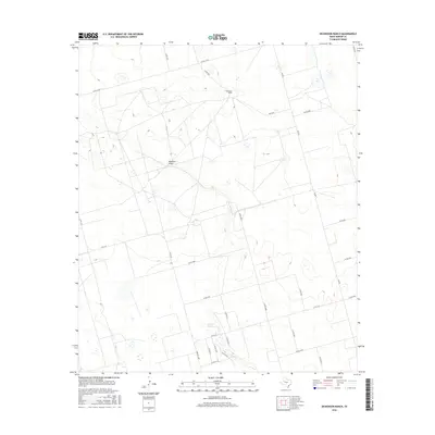
2016 Map of Dickenson Ranch
USGS Topo · Published 2016About this map
Mustang Spring and the ephemeral Mustang Draw characterize this section of Martin County, where the high plains landscape is defined by traditional ranching and a sparse but precise network of county roads. The namesake Dickenson Ranch serves as a primary landmark in a region where water sources and topographic depressions—represented by several small wetlands—have historically dictated the placement of homesteads and grazing lands. The map reveals a rigid grid of transportation, anchored by Farm Rd 1208 and Fm 829, providing a window into the modern rural infrastructure that supports the West Texas cattle industry. This 2016 survey captures the area before significant changes in land use, preserving the location of family-named ranch lands and critical natural springs.
Find a feature on this map
24 named features on this map. Tap any name to fly to it.
Don’t see what you’re looking for? This feature index may not catch every label — zoom into the map to look around manually.
Map Details
Editions of this 2016 Dickenson Ranch Map
This is the sole edition of this map. No revisions or reprints were ever made.
Other maps of this area

1954 · Hobbs
USGS Topo · 1:250,000

1954 · Big Spring
USGS Topo · 1:250,000

1958 · Big Spring
USGS Topo · 1:250,000

1958 · Hobbs
USGS Topo · 1:250,000

1965 · Northeast Midland
USGS Topo · 1:24,000

1966 · Lenorah West
USGS Topo · 1:24,000

1966 · Flynt Ranch
USGS Topo · 1:24,000
1966 · Germania
USGS Topo · 1:24,000

1966 · North Curtis Ranch
USGS Topo · 1:24,000

1966 · Stanton
USGS Topo · 1:24,000