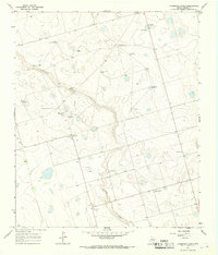
1966 Map of Dickenson Ranch
USGS Topo · Published 1969About this map
Mustang Draw cuts a broad, dry path across this Martin County landscape, defining the topography of the High Plains during the mid-1960s. The region is characterized by an extensive network of groundwater extraction points, essential for the ranching and agricultural operations that sustain the area. Named landmarks such as the Doggie Windmill, Rattlesnake Windmill, and Northeast Sunflower Windmill serve as critical navigational aids and historical markers of individual ranching holdings. At the namesake Dickenson Ranch, the map reveals a concentrated cluster of structures and gravel pits, while the small settlement of Courtney sits further south along the draw. The inclusion of an Aqueduct and scattered oil and gas infrastructure, including a specific Oil Well and Gas Well, highlights the evolving industrial footprint of the Permian Basin era, where traditional ranching began to coexist with energy extraction.
Find a feature on this map
20 named features on this map. Tap any name to fly to it.
Don’t see what you’re looking for? This feature index may not catch every label — zoom into the map to look around manually.
Map Details
Editions of this 1966 Dickenson Ranch Map
This is the sole edition of this map. No revisions or reprints were ever made.
Other maps of this area

1954 · Hobbs
USGS Topo · 1:250,000

1954 · Big Spring
USGS Topo · 1:250,000

1958 · Big Spring
USGS Topo · 1:250,000

1958 · Hobbs
USGS Topo · 1:250,000

1965 · Northeast Midland
USGS Topo · 1:24,000

1966 · Lenorah West
USGS Topo · 1:24,000

1966 · Flynt Ranch
USGS Topo · 1:24,000
1966 · Germania
USGS Topo · 1:24,000

1966 · North Curtis Ranch
USGS Topo · 1:24,000

1966 · Stanton
USGS Topo · 1:24,000