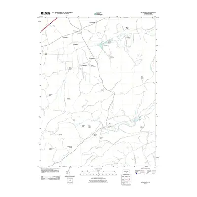
2010 Map of Dickinson
USGS Topo · Published 2010About this map
Pine Grove Furnace serves as a historic anchor in the southern portion of this Cumberland County landscape, where industrial history meets modern recreation. The presence of the Pine Grove Furnace Stack and the Tomstown Dolomite Quarry reflects the area's legacy of resource extraction and iron production. To the north, the terrain transitions into a valley of small settlements and family-named roads, including Dickinson, Brushtown, and Hockersville. The Yellow Breeches Creek meanders through the northern lowlands, supporting the Huntsdale State Fish Hatchery. Significant cultural landmarks like Longsdorfs Cemetery and the site of Camp Michaux offer specific points of interest for genealogists and local historians. The ridge lines are defined by gaps such as Kings Gap Hollow within Kings Gap State Park, while the Appalachian Trl traverses the high ground near Sunset Rocks and Pole Steeple.
Find a feature on this map
86 named features on this map. Tap any name to fly to it.
Don’t see what you’re looking for? This feature index may not catch every label — zoom into the map to look around manually.
Map Details
Editions of this 2010 Dickinson Map
This is the sole edition of this map. No revisions or reprints were ever made.
Other maps of this area

1904 · Carlisle
USGS Topo · 1:62,500

1908 · Gettysburg
USGS Topo · 1:62,500

1909 · Fairfield
USGS Topo · 1:62,500

1919 · Newville
USGS Topo · 1:62,500

1942 · Gettysburg
USGS Topo · 1:125,000

1943 · Carlisle
USGS Topo · 1:62,500

1944 · Flat Ridge
USGS Topo · 1:31,680

1944 · Arendtsville
USGS Topo · 1:31,680
1944 · Biglerville
USGS Topo · 1:31,680

1945 · Newville
USGS Topo · 1:62,500
Featured Places
- Dickinson, Penn Township
- Southampton Township, PA
- Tyrone Township, PA
- Cooke Township, PA
- South Newton Township, PA