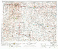
1953 Map of Dickinson
USGS Topo · Published 1978About this map
Dickinson serves as the central hub of this West Dakota landscape, situated along the Northern Pacific railroad and U S 10. The 1950s terrain is defined by a succession of high plains landmarks, including the badlands of Theodore Roosevelt National Memorial Park (South Unit) and the prominent heights of Black Butte and White Butte. To the south, the Chicago Milwaukee St Paul and Pacific line connects ranching and agricultural centers like Mott, Hettinger, and Marmarth near the Little Missouri River. Environmental conservation is noted through the White Lake National Wildlife Refuge and Stewart Lake National Wildlife Refuge. The presence of a Strip Mine near the Cannonball River suggests the early industrial footprint of coal extraction in the region during this mid-century period.
Find a feature on this map
117 named features on this map. Tap any name to fly to it.
Don’t see what you’re looking for? This feature index may not catch every label — zoom into the map to look around manually.
Map Details
Editions of this 1953 Dickinson Map
2 editions found
Other maps of this area

1909 · Glendive
USGS Topo · 1:250,000

1935 · Reva
USGS Topo · 1:125,000

1935 · Buffalo
USGS Topo · 1:125,000

1938 · Heart Butte
USGS Topo · 1:48,000

1944 · Heart Butte
USGS Topo · 1:62,500

1953 · McIntosh
USGS Topo · 1:250,000

1953 · Miles City
USGS Topo · 1:250,000

1953 · Dickinson
USGS Topo · 1:250,000

1953 · Watford City
USGS Topo · 1:250,000

1954 · Lemmon
USGS Topo · 1:250,000