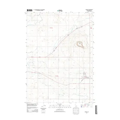
2013 Map of Dietrich
USGS Topo · Published 2013About this map
Dietrich serves as the primary settlement center on this Idaho high-desert landscape, situated at the junction of the Dietrich Hwy and Id-24. The town is organized along a grid including N Main Ave and N Washington St, surrounded by an extensive network of irrigation infrastructure essential to regional agriculture. The Milner Gooding Canal and Lincoln Canal traverse the territory, diverting water from the Big Wood River and Little Wood River to support the local farms. To the northeast, the distinct volcanic topography of Crater Butte rises above the plains, providing a significant geological landmark. The map detail shows how the landscape is partitioned by a rigid section-line road system, with routes like S Highway 93 and Malleya Rd following the township and range lines of t5s r18e and t6s r18e.
Find a feature on this map
38 named features on this map. Tap any name to fly to it.
Don’t see what you’re looking for? This feature index may not catch every label — zoom into the map to look around manually.
Map Details
Editions of this 2013 Dietrich Map
This is the sole edition of this map. No revisions or reprints were ever made.
Other maps of this area

1955 · Twin Falls
USGS Topo · 1:250,000

1955 · Hailey
USGS Topo · 1:250,000

1958 · Twin Falls
USGS Topo · 1:250,000

1959 · Hailey
USGS Topo · 1:250,000

1962 · Hailey
USGS Topo · 1:250,000

1971 · Shoshone SE
USGS Topo · 1:24,000

1971 · Star Lake
USGS Topo · 1:24,000

1971 · Dietrich
USGS Topo · 1:24,000
1971 · Shoshone SW
USGS Topo · 1:24,000

1971 · Dietrich Butte
USGS Topo · 1:24,000