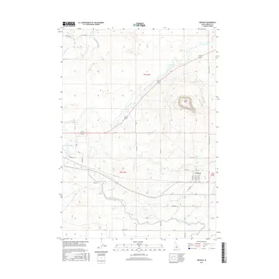
2017 Map of Dietrich
USGS Topo · Published 2017About this map
Dietrich serves as the central hub of this agricultural landscape in southern Idaho, where a complex network of man-made waterways supports the region's productivity. The Little Wood River meanders across the northern and central sections, but it is the extensive irrigation infrastructure that defines the local geography. Significant conduits like the Lincoln Canal and the Milner Gooding Canal are accompanied by numerous numbered branches, such as Lateral 97.8 and Lateral 90.4, illustrating the precision of water management in the high desert. To the east, the prominent volcanic form of Crater Butte rises above the plains, providing a stark geographic contrast to the gridded farm roads and lateral ditches. The map detail extends to the local street names within the town center, including N Washington St and Main St, which cluster near the junction of the Dietrich Hwy and the Kimama Hwy.
Find a feature on this map
40 named features on this map. Tap any name to fly to it.
Don’t see what you’re looking for? This feature index may not catch every label — zoom into the map to look around manually.
Map Details
Editions of this 2017 Dietrich Map
This is the sole edition of this map. No revisions or reprints were ever made.
Other maps of this area

1955 · Twin Falls
USGS Topo · 1:250,000

1955 · Hailey
USGS Topo · 1:250,000

1958 · Twin Falls
USGS Topo · 1:250,000

1959 · Hailey
USGS Topo · 1:250,000

1962 · Hailey
USGS Topo · 1:250,000

1971 · Shoshone SE
USGS Topo · 1:24,000

1971 · Star Lake
USGS Topo · 1:24,000

1971 · Dietrich
USGS Topo · 1:24,000
1971 · Shoshone SW
USGS Topo · 1:24,000

1971 · Dietrich Butte
USGS Topo · 1:24,000