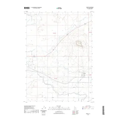
2020 Map of Dietrich
USGS Topo · Published 2020About this map
Dietrich serves as the central hub of this agricultural landscape in Lincoln County, where the desert environment has been transformed by a sophisticated network of irrigation. The town's grid is defined by streets like Main St and N Park St, situated just north of the Dietrich Hwy. The surrounding terrain is dominated by the volcanic presence of Crater Butte, which rises above the complex system of waterways that sustain the region's farms. These waters are managed through an extensive system of canals and laterals, including the Milner Gooding Canal, the Dietrich Main Canal, and the Lincoln Canal. Both the Big Wood River and the Little Wood River traverse the quadrangle, their natural courses supplemented by engineered features like Lateral 964 and the Lateral 912A. Rural life is anchored by family-named roads such as Malleya Rd and Messervy Rd, tracing the legacy of settlement in this high-desert region.
Find a feature on this map
44 named features on this map. Tap any name to fly to it.
Don’t see what you’re looking for? This feature index may not catch every label — zoom into the map to look around manually.
Map Details
Editions of this 2020 Dietrich Map
This is the sole edition of this map. No revisions or reprints were ever made.
Other maps of this area

1955 · Twin Falls
USGS Topo · 1:250,000

1955 · Hailey
USGS Topo · 1:250,000

1958 · Twin Falls
USGS Topo · 1:250,000

1959 · Hailey
USGS Topo · 1:250,000

1962 · Hailey
USGS Topo · 1:250,000

1971 · Shoshone SE
USGS Topo · 1:24,000

1971 · Star Lake
USGS Topo · 1:24,000

1971 · Dietrich
USGS Topo · 1:24,000
1971 · Shoshone SW
USGS Topo · 1:24,000

1971 · Dietrich Butte
USGS Topo · 1:24,000