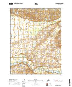
2019 Map of Dillingham A-1 SE
USGS Topo · Published 2019About this map
Alagnak Wild and Scenic River dominates the southern reaches of this landscape, where the meandering course of the Alagnak River creates a complex hydrological network of oxbows and wetlands. Located in the Lake and Peninsula Borough, this area is defined by its status as a federally protected waterway, highlighting the preservation of one of Alaska's premier wild river systems. The transition from the high tundra plains to the river corridor is marked by the Alagnak Wild River corridor, which remains largely untouched by permanent settlement or infrastructure. Mapping from this era captures the intricate drainage patterns and the precise township boundaries, including t13s r41w and t12s r40w, which organize this vast, open territory for administrative and conservation purposes.
Find a feature on this map
7 named features on this map. Tap any name to fly to it.
Don’t see what you’re looking for? This feature index may not catch every label — zoom into the map to look around manually.
Map Details
Editions of this 2019 Dillingham A-1 SE Map
This is the sole edition of this map. No revisions or reprints were ever made.
Other maps of this area

1948 · Mt Katmai
USGS Topo · 1:250,000

1951 · Dillingham
USGS Topo · 1:250,000

1951 · Mt Katmai
USGS Topo · 1:250,000

1951 · Naknek D-1
USGS Topo · 1:63,360

1951 · Mount Katmai D-6
USGS Topo · 1:63,360

1951 · Iliamna A-8
USGS Topo · 1:63,360

1951 · Dillingham A-1
USGS Topo · 1:63,360

1952 · Iliamna
USGS Topo · 1:250,000

1952 · Naknek
USGS Topo · 1:250,000
1952 · Iliamna A-8
USGS Topo · 1:63,360