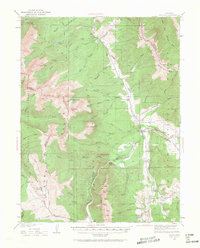
1929 Map of Dillon
USGS Topo · Published 1962About this map
Dillon and Frisco serve as the primary hubs in this high-altitude study of the Central Rockies, documented before the valley's landscape was fundamentally altered by modern water management. The topography centers on the confluence of the Blue River and Tenmile Creek, a vital intersection for local travel and industry. To the west, the massive peaks of the Gore Range rise sharply, including Buffalo Mtn and Red Peak, while the Tenmile Range dominates the southern sector with its numbered summits from Peak 1 to Peak 5. Evidence of the region's mining and transportation history is scattered throughout the drainages, from the high Boss Mine north of Keller Mtn to the small rail-side stops at Dickey and Braddocks. The map also captures early crossing points like Vail Pass and Shrine Pass, along with the Gore Range Trail winding through the White River National Forest.
Find a feature on this map
80 named features on this map. Tap any name to fly to it.
Don’t see what you’re looking for? This feature index may not catch every label — zoom into the map to look around manually.
Map Details
Editions of this 1929 Dillon Map
2 editions found
Other maps of this area

1889 · Leadville
USGS Topo · 1:125,000

1891 · Leadville
USGS Topo · 1:125,000

1924 · Montezuma
USGS Topo · 1:62,500

1924 · Fraser
USGS Topo · 1:62,500

1926 · Fraser
USGS Topo · 1:62,500

1926 · Montezuma
USGS Topo · 1:62,500

1929 · Dillon
USGS Topo · 1:62,500

1933 · Mt. Powell
USGS Topo · 1:48,000

1933 · Montezuma
USGS Topo · 1:62,500

1933 · Ute Peak
USGS Topo · 1:62,500