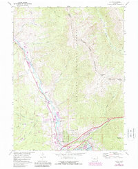
1970 Map of Dillon
USGS Topo · Published 1988About this map
Silverthorne and Dillon serve as the primary hubs in this high-altitude landscape, documented at a time of significant transition. The map captures the infrastructure supporting the growing recreation and residential economy, including the Dillon Reservoir and the Blue River Ranch Lakes development. While the valley floor shows signs of expansion through features like Mesa Cortina and a Trailer Park, the surrounding high country remains dominated by the Arapaho National Forest and the Eagles Nest Wilderness. This survey highlights the complex drainage system of the Blue River, fed by numerous high-mountain tributaries such as Maryland Creek and Straight Creek. The network of the Gore Range Trail and various pack trails reveals how researchers can trace the movement between the developed valley and the alpine summits of Ptarmigan Peak and Tenderfoot Mountain.
Find a feature on this map
39 named features on this map. Tap any name to fly to it.
Don’t see what you’re looking for? This feature index may not catch every label — zoom into the map to look around manually.
Map Details
Editions of this 1970 Dillon Map
3 editions found
Other maps of this area

1924 · Montezuma
USGS Topo · 1:62,500

1924 · Fraser
USGS Topo · 1:62,500

1926 · Fraser
USGS Topo · 1:62,500

1926 · Montezuma
USGS Topo · 1:62,500

1929 · Dillon
USGS Topo · 1:62,500

1933 · Montezuma
USGS Topo · 1:62,500

1933 · Ute Peak
USGS Topo · 1:62,500

1934 · Dillon
USGS Topo · 1:62,500

1937 · Ute Peak
USGS Topo · 1:62,500

1953 · Denver
USGS Topo · 1:250,000