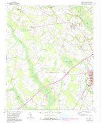
1960 Map of Dillon West
USGS Topo · Published 1980About this map
Dillon and its western rural hinterlands appear in this 1960 topography, updated with late-1970s land use changes. The landscape is defined by the winding course of the Little Pee Dee River and the expansive Betsy Jackson Bay, interspersed with the distinct agricultural and residential patterns of the South Carolina Coastal Plain. The area is anchored by several rural nodes like Little Rock and McCormick Crossroads, which serve as focal points for local commerce and community life.
Find a feature on this map
40 named features on this map. Tap any name to fly to it.
Don’t see what you’re looking for? This feature index may not catch every label — zoom into the map to look around manually.
Map Details
Editions of this 1960 Dillon West Map
2 editions found
Other maps of this area

1942 · Rockingham
USGS Topo · 1:125,000

1943 · Gum Swamp
USGS Topo · 1:62,500

1953 · Florence
USGS Topo · 1:250,000

1954 · Florence
USGS Topo · 1:250,000

1959 · Fork
USGS Topo · 1:24,000

1960 · Latta
USGS Topo · 1:24,000

1960 · Dillon East
USGS Topo · 1:24,000

1960 · Dillon West
USGS Topo · 1:24,000

1971 · Minturn
USGS Topo · 1:24,000

1972 · Clio
USGS Topo · 1:24,000