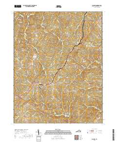
2019 Map of Dillwyn
USGS Topo · Published 2019About this map
Dillwyn serves as the central hub of this Buckingham County landscape, where the intersection of S Constitution Rte and local thoroughfares marks a cluster of civic and residential growth. The surrounding terrain is defined by a dense network of creek drainages, including Turpin Cr, Whispering Cr, and Buffalo Cr, which carve through the Piedmont topography toward the Slate River. This area is particularly notable for its high concentration of family and community burial grounds, such as Mourning Valley Cem, Ayers Cem, and Wade Cem, reflecting generations of settlement in communities like Alpha and Rosney.
Find a feature on this map
91 named features on this map. Tap any name to fly to it.
Don’t see what you’re looking for? This feature index may not catch every label — zoom into the map to look around manually.
Map Details
Editions of this 2019 Dillwyn Map
This is the sole edition of this map. No revisions or reprints were ever made.
Other maps of this area

1891 · Palmyra
USGS Topo · 1:125,000

1891 · Farmville
USGS Topo · 1:125,000

1892 · Buckingham
USGS Topo · 1:125,000

1892 · Appomattox
USGS Topo · 1:125,000

1893 · Farmville
USGS Topo · 1:125,000

1895 · Palmyra
USGS Topo · 1:125,000

1897 · Palmyra
USGS Topo · 1:125,000

1947 · Roanoke
USGS Topo · 1:250,000

1950 · Dillwyn
USGS Topo · 1:62,500

1958 · Farmville
USGS Topo · 1:62,500