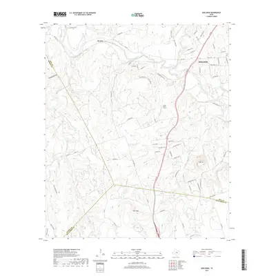
2019 Map of Ding Dong
USGS Topo · Published 2019About this map
Maxdale and the western edge of Killeen anchor this landscape where the Lampasas River winds through the limestone hills of Central Texas. The terrain is defined by dramatic elevation changes, notably at Hog Mtn and along Wolf Ridge, with numerous seasonal drainages such as Gann Br and Sycamore Br feeding the river system. The presence of Fisher Ranch Airport and a dense network of ranch and residential roads, including Sharp Cemetery Rd and River Ridge Ranch Rd, illustrate the area's transition from traditional ranching toward suburban expansion. This survey also documents the tri-county intersection of Bell, Burnet, and Williamson counties, capturing a specific moment of land division near Indian Lake and Tom Adams Hollow. Local waterways like McDaniel Br and Reese Cr carve through the topography, marking the complex drainage patterns typical of this region.
Find a feature on this map
78 named features on this map. Tap any name to fly to it.
Don’t see what you’re looking for? This feature index may not catch every label — zoom into the map to look around manually.
Map Details
Editions of this 2019 Ding Dong Map
This is the sole edition of this map. No revisions or reprints were ever made.
Other maps of this area

1893 · Georgetown
USGS Topo · 1:125,000

1894 · Gatesville
USGS Topo · 1:125,000

1930 · Killeen
USGS Topo · 1:62,500

1947 · Fort Hood
USGS Topo · 1:62,500

1947 · Killeen
USGS Topo · 1:62,500

1947 · McMillan Mountains
USGS Topo · 1:24,000

1947 · Killeen
USGS Topo · 1:24,000

1947 · Copperas Cove
USGS Topo · 1:24,000

1954 · Waco
USGS Topo · 1:250,000

1954 · Austin
USGS Topo · 1:250,000