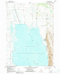
1967 Map of Dingle
USGS Topo · Published 1991About this map
The Bear Lake National Wildlife Refuge dominates this landscape, protecting the expansive wetlands and marshes of the Dingle Swamp. This 1960s environment is defined by an intricate network of water management, where the Bear River is diverted through the Rainbow Canal and regulated via several Gaging Stations and a Diversion Dam. To the east, the terrain rises sharply from the valley floor toward Merkley Mountain and the prominent Lake Ridge, providing a stark contrast to the low-lying basins of Mud Lake and the Bear Lake Outlet. Settlement is concentrated in the small community of Dingle, which sits at the edge of the irrigation systems. For genealogists and local historians, the map identifies specific points of interest including the Dingle Cem and the Bear Lake County Airport, alongside various Gravel Pits and Prospects that indicate the local extractive activity of the era.
Find a feature on this map
22 named features on this map. Tap any name to fly to it.
Don’t see what you’re looking for? This feature index may not catch every label — zoom into the map to look around manually.
Map Details
Editions of this 1967 Dingle Map
2 editions found
Other maps of this area

1909 · Montpelier
USGS Topo · 1:125,000

1911 · Montpelier
USGS Topo · 1:125,000

1955 · Preston
USGS Topo · 1:250,000

1958 · Preston
USGS Topo · 1:250,000

1962 · Preston
USGS Topo · 1:250,000

1967 · Montpelier
USGS Topo · 1:24,000

1967 · Paris
USGS Topo · 1:24,000

1967 · Ovid
USGS Topo · 1:24,000

1967 · Dingle
USGS Topo · 1:24,000
1969 · St Charles
USGS Topo · 1:24,000