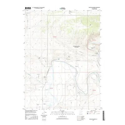
2017 Map of Dinosaur Quarry
USGS Topo · Published 2017About this map
The Green River meanders through this landscape, carving deep into the geological formations of Dinosaur National Monument and Split Mountain Canyon. This 2017 survey highlights the proximity of the iconic Dinosaur Quarry to the small settlement of Jensen, where the Jensen Cem and local road networks like S 9500 E serve the resident community. The map illustrates a transition from the preserved fossil beds and interpretive paths, such as the Fossil Discovery Trail and Sound of Silence Trail, to the active ranching and infrastructure of the valley floor.
Find a feature on this map
38 named features on this map. Tap any name to fly to it.
Don’t see what you’re looking for? This feature index may not catch every label — zoom into the map to look around manually.
Map Details
Editions of this 2017 Dinosaur Quarry Map
This is the sole edition of this map. No revisions or reprints were ever made.
Other maps of this area

1885 · Ashley
USGS Topo · 1:250,000

1907 · Jensen
USGS Topo · 1:125,000

1910 · Jensen
USGS Topo · 1:125,000

1954 · Vernal
USGS Topo · 1:250,000

1955 · Island Park
USGS Topo · 1:24,000

1955 · Split Mountain
USGS Topo · 1:24,000

1958 · Vernal
USGS Topo · 1:250,000

1960 · Vernal
USGS Topo · 1:250,000
1965 · Donkey Flat
USGS Topo · 1:24,000
1965 · Dinosaur Quarry
USGS Topo · 1:24,000