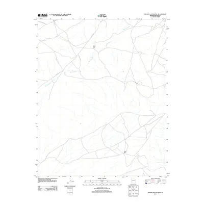
2011 Map of Dipping Water Well
USGS Topo · Published 2011About this map
Wide Ruin Wash defines the drainage patterns across this high desert landscape, carving its way toward the southwestern corner of the quadrangle. The area is characterized by sparse water resources, with essential infrastructure represented by locations like the Dipping Water Well and John Joe Well. This region within the Fort Defiance Agency demonstrates a network of transit routes spanning the terrain, from established paths like Indian Rte 9401 to specialized tracks such as Blue Metal Rd. To the south, the elevation rises toward the prominent landmark of Padres Mesa, while the northern reaches are accessed via Dead Wood Mesa Rd. The mapping of these specific wells and mesa names provides a clear record of the geographic points of reference used in this part of Apache County in the early twenty-first century.
Find a feature on this map
8 named features on this map. Tap any name to fly to it.
Don’t see what you’re looking for? This feature index may not catch every label — zoom into the map to look around manually.
Map Details
Editions of this 2011 Dipping Water Well Map
This is the sole edition of this map. No revisions or reprints were ever made.
Other maps of this area

1886 · Fort Defiance
USGS Topo · 1:250,000

1892 · Fort Defiance
USGS Topo · 1:250,000

1954 · Gallup
USGS Topo · 1:250,000

1958 · Gallup
USGS Topo · 1:250,000

1959 · Gallup
USGS Topo · 1:250,000

1962 · Gallup
USGS Topo · 1:250,000

1967 · Gallup
USGS Topo · 1:250,000

1971 · Wide Ruins
USGS Topo · 1:24,000
1971 · Chambers
USGS Topo · 1:24,000
1971 · Wide Ruins SW
USGS Topo · 1:24,000